

Guide to Gayndah and the North Burnett Region
Gayndah and the North Burnett region of Queensland is only 326kms from Brisbane yet offers so many activities for both adults and children alike.
It should not be overlooked as an easy to drive to tourist destination for those interested in seeing more of Queensland.
Nothing behind me, everything ahead of me, as is ever so on the road.
– Jack Kerouac –
Disclosure: This post contains affiliate links. This means that if you click on our affiliates / advertisers links and make a purchase, we may receive a small commission, but at no extra cost to you. AND, many times, you will receive an offer. Win/win! The products and services we write about and mention are the ones we love. We only recommend items that we feel are of good quality and would be helpful to our readers. While we pay for our travels out of our own pockets, these small commissions do assist in keeping us on the road. Thank you!
Introduction to the North Burnett Region, Queensland
The North Burnett is home to a unique collection of towns, villages, districts and destinations that are quite diverse and worthy of discovering.
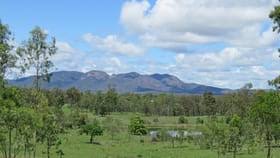
You’ll discover rugged gorges, imposing mountain ranges, serene rural views, the Burnett River and numerous townships along the way offering country hospitality. You can camp in a National Park, bushwalk, throw in a line or go tubing and skiing on the many dams, enjoy fresh produce from numerous roadside stalls or step back in time at a historical museum.
If it’s organised activities you are looking for, there is hardly a weekend where you won’t find something happening across the region. Festivals and celebrations are regular events and with a number of picnic races scheduled throughout the year there is plenty of opportunity to get out, socialise and have some fun.
If golf is your way of relaxing, you will find a Golf Club in each of the six townships. From fitness to fishing, you will find a community that shares your passions and you will always have something to do.
Map of the North Burnett

Population of North Burnett Regional Areas
Total = 10,600 (2020)
Population of Gayndah
Total = 1,981 (2016)
Population of Mundubbera
Total = 1,261 (2016)
Population of Eidsvold
Total = 574 (2016)
Population of Monto
Total = 1,189 (2016)
Population of Mount Perry
Total = 538 (2016)
Population of Biggenden
Total = 845 (2016)
Getting There – Road, Bus
By Road
The region is best discovered by hire-car or vehicle transport.
Route Planner / Road Distances
| Bundaberg | ||||||
| 100 | Biggenden | |||||
| 162 | 62 | Gayndah | ||||
| 206 | 106 | 46 | Mundubbera | |||
| 168 | 143 | 78 | 35 | Eidsvold | ||
| 194 | 164 | 152 | 108 | 73 | Monto | |
| 100 | 70 | 70 | 73 | 68 | 94 | Mount Perry |
By Bus
The North Burnett Transport Service offers the following services:
- Tuesday – Mundubbera to Bundaberg
- Wednesday – Mundubbera to Bundaberg (via Eidsvold)
- Thursday – Mundubbera to Bundaberg
- Friday – Mundubbera to Maryborough
Weather in the North Burnett – When Should I Visit?
The North Burnett region experiences a subtropical climate with warm wet summers and mild winters. The average annual temperature is 20°C. The Summer average temperature is 25°C, Autumn 21°C, Winter 15°C and Spring 21°C.
Safety
Queensland is a relatively safe place to visit – in terms of crime and war, at any rate – but take reasonable precautions as you would anywhere.
- Bushfires, floods and cyclones regularly decimate parts of Queensland: pay attention to warnings from local authorities.
- Use sunscreen and cover up to avoid sunburn and heat sickness.
- Cover up at dusk and wear insect repellent to deter mosquitoes and ticks.
- Snakes are active in summer and common on bushwalking trails: wear boots, socks and long trousers (ideally gaiters).
We highly recommend purchasing travel insurance when travelling overseas. Insurance will cover important things like emergency medical hospitalisation / evacuation, baggage delays and trip cancellation. We recommend SafetyWing for quality travel insurance you can trust, at affordable rates.
BOOK: Buy Travel Insurance Here

Major Events Calendar
| JANUARY | JULY |
| Australia Day | Eidsvold Polocrosse Gayndah Heartland Festival NAIDOC Celebrations in all towns |
| FEBRUARY | AUGUST |
| Biggenden Campdraft Wuruma Dam Fishing Competition | Biggenden Riff n Tuff Charity Car Show Mingo Crossing Catch a Catty Fishing Competition Biggenden Campdraft |
| MARCH | SEPTEMBER |
| Cania Dam Fishing Competition Monto Annual Race Day Monto Prime Cattle Show Eidsvold Campdraft Mount Perry Campdraft Mundubbera Campdraft | Gayndah Family Fishing Competition Mundubbera Fishing Competition Mulgildie Rodeo Mundubbera Long Table Banquet Monto Dairy Festival |
| APRIL | OCTOBER |
| ANZAC Day Celebrations Gayndah Agricultural Show Mount Perry Show Monto Agricultural Show Eidsvold Cattle Drive | Mount Perry Axeman’s Sawyers Woodchop Monto Spring Markets and Flower Show Eidsvold Springtime Flower Show Eidsvold Races Gayndah Cup Biggenden Rose Festival |
| MAY | NOVEMBER |
| Gayndah Orange Festival (biannual) Eidsvold Agricultural Show Mundubbera Agricultural Show Biggenden Agricultural Show Gayndah Silver Whip Campdraft Mulgildie Campdraft | Mount Perry RacesEidsvold Heritage Day |
| JUNE | DECEMBER |
| Ganydah Races Monto Annual Cattle Drive Monto Store Cattle and Show Sale Monto Cattle Drive and Trail Ride Monto Silver Buckle Challenge and Campdraft Monto Polocrosse | Christmas celebrations in all major towns |
What Does the North Burnett Region Have to Offer?
Produce Grown / Industry
The region is based on an agricultural economy, and every form of farming enterprise exists. With the twin citrus capitals of Gayndah and Mundubbera, to some of the best beef studs in the country right through to dairying, pork production and small crops. Feed your senses with the sheer diversity of the local produce you can expect to find in the region.
Culture and Arts
North Burnett Art Trail
The North Burnett has a thriving and every changing art scene that is as diverse and beautiful as the towns they are found in. The art trail consists of silos, water towers, murals, sculptures, galleries and more!
Biggenden
Features in Biggenden include 3 steel sculptures in the main street, all creatively built by talented locals.

Gayndah
Gayndah Art Gallery is found at 34 Meson Street and is open Tuesday – Sunday from 10:00am to 2:00pm.
Mundubbera
Bicentennial Park features a steel sculpture trail depicting the region’s people and wildlife. Murals to see are:
- Town Hall mural
- Library building – collaboration featuring local artists celebrating the history of the Mundubbera Art Gallery
- Jaycee Park (Black Stump Rest Area) – Mural by Indigenous artist, Malcolm Brown
- Water Tower – “Meeting of the Waters” Mural.
Mundubbera Regional Art Gallery is found on Lyon Street and is open Monday – Friday: 8:30am to 11:30am, 12:30pm to 4:30pm, Saturday 9:00am to 12:00pm
Eidsvold
RM Williams Australian Bush Learning Centre’s gallery space features local and exhibiting artists with a ‘bush theme’. The Centre is open Monday – Friday, 8:30am to 4:30pm and Weekends, 10:00am to 2:00pm.
Street Art – In the main street there are buildings that have been painted by Indigenous community members featuring traditional and contemporary techniques.
Monto
Monto has a vibrant public art trail across town. These include:
- Three Moon Silos
- Murals on walls in Newton Street
- Water Tower in Rotary Park
- Painted Cow Trail
- Art Gallery at the Monto Historical Complex (open Thursday 10:00am to 1:00pm)
- Lister Street Sculpture Art Walk
- Water Tank Art

Mount Perry
Pat Augustine Cultural Centre is home the Shelly Kelly Art Gallery that features local and touring artists. The Centre is also home to a wallpaper collection of Mount Perry born Florence Broadhurst originals. Florence was known internationally for her bright and vibrant prints on wallpaper.
National Parks – Walking Tracks / Hikes / Mountain Bike Trails
The North Burnett Region has an abundance of National Parks and mountain ranges with a walking track never too far away.
Auburn River National Park
Auburn River National Park is located approximately 255km west of Maryborough or 36km south-west of Mundubbera. There are a number of walking tracks on offer:
Walking Tracks / Hikes
1. Gorge Lookout Walk
Distance: 600m return (allow 15 minutes)
Leaving the end of the carpark, take this short track for spectacular views of the Auburn River Gorge and its incredible boulders.
2. Riverbed and Rock Pools Walk
Distance: 1.5km return (allow 1 hour)
For experienced and fit hikers, walk the track down the side of the gorge to the river through spectacular vegetation and rainforest.
3. Gorge Top Walk
Distance: 3.2km return (allow 1.5 hours)
Take this gentle walk along the river, through the greenery of the forest, for incredible views down the river.
Cania Gorge National Park
Explore the sandstone wilderness of Cania Gorge National Park and discover Aboriginal free-hand art along towering cliffs, in ancient caves and sheltered gorges.
Walking Tracks / Hikes
From Three Moon Creek picnic area:
1. Picnic Area Circuit
Distance: 300m return (allow 20 minutes)
Take this short walk along Three Moon Creek for views of the famous sandstone cliffs.
2. Dripping Rock and The Overhang
Distance: 3.2km return (allow 2.5 hours)
Cross Three Moon Creek through woodlands to the impressive Dripping Rock and onto The Overhang, where centuries of weather has eroded the base of the cliff.
3. Big Foot Walk
Distance: 1km return (allow 45 minutes)
Wander this short walk and keep an eye out for an image of a foot on the base of the cliff.
4. Fern Tree Pool and Giants Chair Circuit
Distance: 5.6km return (allow 3 hours)
Pass the spectacular fern tree gully and make your way to the Giants Chair Lookout for views like you’ve never seen before.
5. Dragon and Bloodwood Caves
Distance: 2.6km return (allow 1 hour)
Make your way along this track to see a mural of a ‘dragon’ on the sandstone wall, then continue to the Bloodwood cave.
6. Two Storey Cave Circuit
Distance: 1.3km (allow 45 minutes)
Hike this beautiful track up to a breathtaking cave, which is also a haven for bats.
7. Castle Mountain
Distance: 22km (allow 7-8 hours)
Only for experienced bushwalkers, this track provides hikers with two spectacular lookouts – the Gorge lookout with views down the gorge and Castle Mountain lookout with views over Lake Cania.
From the northern carpark:
8. Shamrock Mine Site
Distance: 1.4km return (allow 45 minutes)
Discover this old gold mine site, part of the Cania Goldfields. See mineshafts, processing sheds and more.


Coalstoun Lakes National Park
Formed over 600,000 years ago, Mount Le Brum is one of the youngest volcanic formations in Australia. Not for the faint hearted, this short sharp hike up leads to two craters which form shallow lakes throughout the year. From the top enjoy panoramic views of the surrounding landscape.
Walking Tracks / Hikes
- Coalstoun Lakes Walking Track
Distance: 4.4km return (allow 2-3 hours)
Only for experienced bushwalkers, take the track to see breathtaking views of the first crater lake. Continue through the dry rainforest to the second crater and bird hide. Keep an eye out for wildlife along the way.
Cordalba National Park
Cordalba National Park is surrounded by the Cordalba State Forest, a haven for mountain bikers with its rugged hills and open eucalyptus woodland.
Mountain Bike Trails
1. Trail 1 (Easy)
Distance: 800m return
2. Trail 2 (Easy)
Distance: 7.1km return
3. Trail 3 (Easy)
Distance: 1.25km one way
4. Trail 4 (Easy)
Distance: 1.7km one way
5. Trail 5 (Intermediate)
Distance: 6.7km return
6. Trail 6 (Intermediate)
Distance: 3km one way
7. Trail 7 (Intermediate)
Distance: 10.8km return
8. Trail 8 (Difficult)
Distance: 3km one way
9. Trail 9 (Difficult)
Distance: 2km one way


Goodnight Scrub National Park
Protecting a once impenetrable and extensive hoop forest, Good Night Scrub National Park is a peaceful bush retreat. Have a bush picnic in a picturesque bushland setting at Kalliwa Hut. Keep an eye out for the 166 bird species and the 60 species of butterflies spotted in the park. Take a drive up to One Tree Hill Lookout for views of the North Burnett.
Mount Walsh National Park
A landmark in the North Burnett. This towering National Park is a sight to behold. Stop for an all Aussie family BBQ under the impressive granite Bluff, take on a challenge setting off early morning to walk to the summit or grab your bathers for a swim in the Waterfall Creek Rock Pools Utopia.
Walking Tracks / Hikes
1. Rock Pool Walk
Distance: 3km return (allow 1 hour)
For experienced bushwalkers, take this walk from the Waterfall Creek section car park. During the wet season, a creek cascades through rock pools in the granite from water erosion. Make sure to look out for wildlife along the way.
2. Mount Walsh Summit Route
Summit climb: 462m (allow 4 hours)
Only for experienced bushwalkers with rock scrambling skills. Start by hiking through a dry rainforest and continue up to the summit of this mountain for spectacular views.
Woowoonga National Park
Approximately 93km north-west of Maryborough, Woowoonga National Park is 104km south-west of Bundaberg and 15km north-east of Biggenden. Woowoonga National Park protects 2546ha of rugged and densely forested country along the Woowoonga Range. Hike through dry rainforest and open forest to Mount Woowoonga (620m) for spectacular views over the Biggenden and Maryborough areas.
Walking Tracks / Hikes
1. Lookout Walk
Distance: 106km return (allow 1.5 hours)
A natural lookout is situated approximately 800m along the track. The walk is rated as moderate to strenuous and walkers can take the opportunity to weave through thick dry vine forest.
2. Summit Walk
Summit climb: 3.6km return (allow 5 hours)
A well-defined trail leads through thick vine forest to the lookout before opening up into open hoop pine forest with some vine forest sections in the understorey. Towering hoop pines greet hikers at the summit of Mt Woowoonga.
Wildlife
The best areas to see the amazing wildlife the North Burnett has to offer is in the National Parks listed above. Varieties of wildlife include, but are not limited to:
- Rock-wallabies
- Black-striped wallabies
- Red-necked wallabies
- Brush-tailed rock wallabies
- Eastern grey kangaroos
- Sheath-tail bats
- Bentwing bats
- Micro Bats
- Yellow-bellied gliders
- Butterflies
Birdwatching
Birds are abundant in the National Parks with over 150 species recorded including Rainbow lorikeets, the larger Australian king-parrot and the Lewin’s honeyeaters. You might also see peregrine falcons which nest in the cliffs and wedge-tailed eagles soaring high over the canopies.
The forests are home to red-tailed and glossy black-cockatoos, an uncommon species that feeds almost exclusively on casuarina seeds. The birds mangle the seed pods to the small seed inside and discard the remains of seed pods, called mangled orts, under the trees – a clue to birds feeding there.
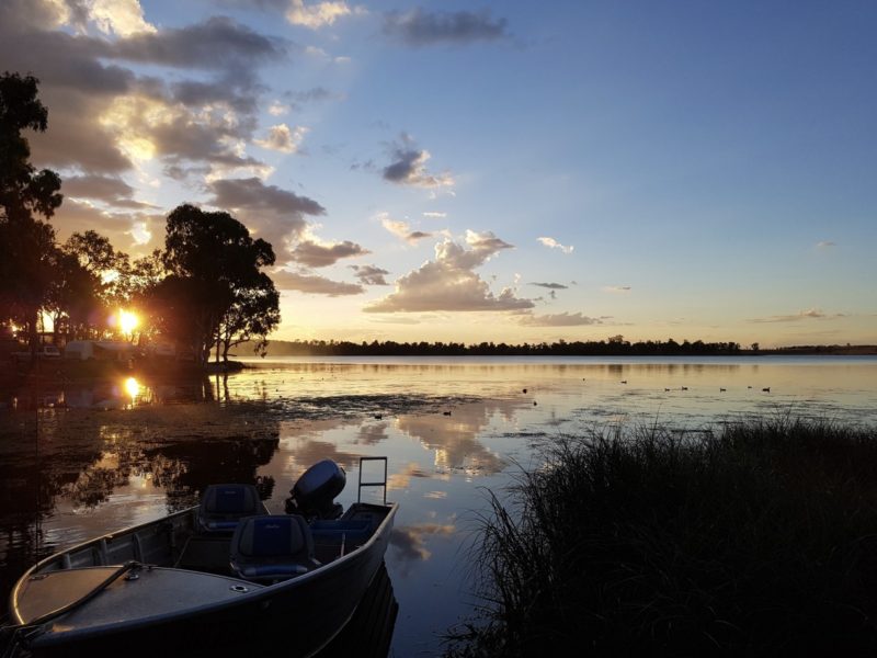
Fishing and Boating
Cania Dam
Picturesque Lake Cania is located approximately 37 kilometres north of Monto and 194 kilometres from Gladstone. The lake is situated on Three Moon Creek, a tributary of the Burnett River. The dam is constructed from earth and rock fill and has a storage capacity of 88,500 megalitres. The short steep walk or easy drive to the lookout is well worth the effort. From here the breathtaking panoramic views of the Gorge’s coloured sandstone cliffs and the spectacular sunsets will leave lasting memories of Cania.
Lake Cania is noted for Saratoga catches. Other species include Bass, Golden Perch (Yellow Belly), Silver Perch, Eel-Tailed Catfish, Spangled Perch, Eel and Snub-Nosed Garfish. Fish stocking occurs three times a year and fishing permits are required all year round.
Claude Wharton Weir
Claude Wharton Weir, named after a state parliamentarian of the late 1900s who was born in Gayndah, is located off the Burnett Highway just north of Gayndah on the Burnett River.
The Burnett River provides excellent recreational fishing. Australian Bass, Barramundi, Golden Perch (Yellow Belly), Spangled Perch and Catfish are the commonly caught species in the Claude Wharton Weir.
Jones Weir
Jones Weir, built in 1951, is located on the Burnett River at Mundubbera. The Mundubbera Apex Ski Area is located four kilometres from the weir along Coonambula Road.
It is a popular year-round recreation facility. Boating, fishing, and water skiing all take place on the waters of Jones Weir.
The weir is stocked with Australian Bass, Barramundi and Yellow Belly. Catfish, Eel and Spangled Perch are also present.
Occasionally, Platypus and Ceratodus, or Lungfish, may be spotted.
Mingo Crossing
Set along the banks of the beautiful Burnett River and upstream from Paradise Dam, Mingo Crossing is surrounded by rural countryside and is only a 30 minute drive from Mount Perry, approximately 125 kilometres west of Bundaberg via Gin Gin.
Mingo Crossing is perfect for all types of water sports including fishing, sailing, skiing and tubing creating a peaceful and relaxed atmosphere.


Paradise Dam
Only a 20 minute drive north-west from the town of Biggenden and 80 kilometers south-west of Bundaberg, lies Paradise Dam on the Burnett River. The dam is named after the old gold mining township of Paradise which now lies under the waters. It was completed in November 2005 after four years of construction and has a capacity of 300 000 megalitres.
Prior to the construction of the dam, the Burnett River was stocked in this area with Australian Bass, Barramundi, Golden Perch and Silver Perch. There are breeding populations of Eel-Tailed Catfish, Fork-Tailed Catfish, Spangled Perch and the endangered Queensland Lungfish.
Wuruma Dam
Noted for its beautiful views and as a venue for fishing and water sports, Wuruma Dam is situated on the Nogo River between Monto and Eidsvold. It lies approximately a 2.5 hour drive west of Bundaberg and has a sealed road access from the Burnett Highway via Abercorn. The dam was built in three years from 1966 at a cost of $5.3 million. It is a mass gravity concrete structure with a storage capacity of 165 400 megalitres.
As a relaxing water recreation facility, Wuruma Dam is suitable for water such as water skiing, power boating, canoeing, sailing, fishing and swimming.
The Wuruma Dam Fish Restocking Association stock fish including Barramundi, Australian Bass, Golden Perch and Silver Perch. There are breeding populations of Eel-Tailed Catfish, Spangled Perch and Eels. Fishing permits are required all year round.
Great Regional Drives
The North Burnett is a real contrast to the coastal parts of the region. You will experience rugged gorges, imposing mountain ranges, serene rural views, the Burnett River and towns offering country hospitality.
The Burnett Circle (Gayndah, North Burnett Area)
Total = 400kms (approx. 144 hours)
This is the stuff Australian landscape paintings are made of. With craggy mountain ranges, bottle and grass trees, waterways, picturesque picnic spots, untouched vast stretches of land and blue sky as far as the eye can see, this is the Burnett Circle.
Biggenden → Paradise Dam → Mingo Crossing → Mt Walsh National Park → Coalstoun Lakes National Park → Ban Ban Springs → Gayndah → Mundubbera → Auburn River National Park → Eidsvold → Lake Wuruma → Monto → Cania Gorge National Park → Lake Cania → Mount Perry

Things to Do – Gayndah and the North Burnett Region
Things to Do in Biggenden
Biggenden rests in a dramatic landscape below the rugged cliffs of Mount Walsh on the Isis Highway 339kms north of Brisbane and just over one hour’s drive from the coastal regions of Bundaberg, Maryborough and Hervey Bay.
It is one of those towns which is easy to pass by, however, you could easily fill in half a day inspecting some of the town’s interesting features.
This township came into existence in 1889 as a service centre to the short-lived goldrush towns of Paradise and Shamrock. During their brief moment of glory they were well serviced by the police and the courts, and by hotels. Paradise reputedly had seven, though some of them were no more than shanties and tents.
Map of Biggenden

Biggenden Mine
Biggenden Mine is located 8 km out of town and is clearly signposted off the Ban Ban Springs Road. It is owned by Poseidon, the legendary company whose shares climbed to astronomical amounts in the share boom of the late 1960’s. The Biggenden Mine is an extraordinary example of how humans can literally convert a mountain into a hole. It has been operating since 1888.
No one knows the exact quantities of minerals extracted from Biggenden Mine but the approximate figures give some indication of the changing focus of mining: approximately 6000 ounces of gold (1888-1901), 200 tons of bismuth (1901-1938) 330,000 tonnes of magnetite (1966 -1990), used in the treatment of export coal. All mining now occurs underground.
Mines are not accessible to the public.
- Where: Clearly signposted 4km from Biggenden off the Biggenden – Gayndah Road
Chowey Bridge
The Chowey Bridge was constructed for the railways and opened in 1905. This concrete bridge is supported by a main 27m concrete arch and a number of smaller arches. The last section of the route to the bridge is down a gravel road. The bridge itself is a beautifully proportioned concrete arch over a deep pool.
- Where: 8 km north west of Biggenden via the Gooroolba-Biggenden Road
- Hours: N/A
- Cost: Free
Coongarra Rock and Falls
For Four Wheel Drive enthusiasts, Coongarra Rock and Falls provide an opportunity to explore rocky outcrops, caves, rock pools and natural vegetation. It is possible to climb the rock but should only be attempted by fit and experienced bushwalkers.
- Where: Lords Road, Biggenden
- Cost: Free Entry
Paradise Dam
Paradise Dam lies on the beautiful Burnett River and is renowned for fresh water fishing. Other water sports which can be enjoyed include boating, skiing, tubing, sailing and swimming.
- Where: 353 Campbells Road, Biggenden
- Cost: Free Entry
Pioneer Sculpture
“The Pioneer” metal art sculpture was created in 2009 by Bundaberg artist Dave Machen. The text accompanying the sculpture points out that it represents “Industries past – timber, cattle, mining. They were men of iron who battled for survival and shaped our modern development.” The sculpture alludes to the remnants of old work sites. The old barrow is a common find throughout the Biggenden area around closed mines, cattle properties and old timber yards.
- Where: Biers Park, Edward Street, Biggenden
- Cost: Free
The Biggenden Historical Museum
The top floor of the former Paradise Court House was relocated to Biggenden after the Paradise Goldfield was exhausted. It became the police station and courthouse and is now home to the Biggenden Museum.
The Society was founded in 1980 and aims to collect, preserve, index and display items of historical interest pertaining to the history of Biggenden and surrounding district; and to promote the Museum and the history of Biggenden.
The Museum contains photographs and memorabilia collected since its opening. A new shed now housed farming implements and items pertaining to the outdoors and life on the land. A room from the old Biggenden Hospital is currently being restored.
- Where: 8 Edward Street, Biggenden
- Hours: Tues and Thurs 9:00am to 3:30pm (all other days by appointment)
- Cost: Free Entry / Donation
The Biggenden Rose
In 2016 the Biggenden Apex Rose Festival saw the unveiling of the Biggenden Rose in Edward Street. The local paper reported “Thanks to RADF funding, which is provided by the Queensland Government and North Burnett Regional Council, Biggenden will have a new permanent street art feature unveiled in Edward Street during the Rose Festival. The Biggenden Rose, created by local artist Craig Nelson, weighs in at close to two tonnes and will make visitors turn their heads for surely they have never seen a rose quite like it.”
- Where: Edward Street, Biggenden
- Cost: Free
Waterfall Creek Rock Pools, Utopia
These impressive rock pools are in the southernmost part of the Mount Walsh National Park. Following rain the quite deep pools cascade over the rocky surface creating a natural slide and an excellent place to cool down on a hot day.
- Where: Utopia Road, second car park marked Mount Walsh National Park
- Cost: Free Entry


Things to Do in Eidsvold
Prior to the arrival of Europeans the area around Eidsvold was home to the Wakka Wakka Aboriginal people.
Eidsvold was settled by Europeans in 1848 when the Archer brothers, Thomas and Charles, moved into the area establishing large stations. Thomas called his Eidsvold. The Archers started grazing sheep but soon changed to cattle. It is said that Australia’s first game of golf was played at Eidsvold station, which was also the first Australia stud to use Santa Gertrudis cattle.
As early as 1858 gold was found in the area but not in sufficient quantities to attract prospectors. In 1886 a Mr Achilles found gold and the resulting rush created an overnight township which had,”8 public houses, 8 stores, 2 bakers, 2 butchers, will all other trades except shoemaker, R.C. Church, Salvation Army Barracks, 1 dance saloon, 2 steam sawmills and a population of about 1200.’ It is estimated that during the life of the goldmine about 100,000 ounces of gold were extracted from the area.
Map of Eidsvold

Archer Homestead
Archer Homestead, the home of the pioneering settlers Thomas and Charles Archer, rests on the banks of the Burnett River, just as it was over 100 years ago. The Homestead is left exactly as it was when the Archer’s settled the area.
- Where: 8km west of Eidsvold, Eidsvold
- Hours: View by Appointment only (contact the Visitor Information Centre – 1300 696 272)
- Cost: Free Entry
Ceratodus Rest Area
The attractive Ceratodus rest area houses memorabilia from the old Ceratodus railway siding days. Ceratodus is the name given to the unique lungfish found in the Burnett and Mary Rivers. A cairn to commemorate the Traylan Native Police Barracks takes pride of place in the grounds.
- Where: Burnett Highway, Eidsvold (10km north of Eidsvold)
- Cost: Free Entry
Eidsvold Historical Museum
The Eidsvold Historical Complex is home to a fine collection of historic buildings including the “Knockbreak” homestead, a slab building built in the late 1850s and the original Clonave Homestead which was moved to the Complex from Clonave Station west of Eidsvold. The Young family were the original owners of the property and their descendants still reside there.
The Riverleigh Cottage was formerly a railway worker’s cottage and houses memorabilia including the Eidsvold Soldiers’ corner, a display of photographs, medals and equipment from the various wars, traditional owner’s artefacts, slates and desks and other school equipment and a manual telephone exchange.
The museum also houses the George Schafer geological collection and the Duncan and Schultz bottle collection, a collection of several thousand bottles and pioneering tools.
- Where: 2 Mt Rose Street, Eidsvold
- Hours: Mon and Fri 9:00am to 12:00pm
- Cost: Adult $5, Child free
RM Williams Australian Bush Learning Centre
The legendary RM Williams ’footprints are firmly imprinted in Eidsvold’s history and his name graces a centre dedicated to preserving and reviving the area’s unique bush culture. Discover the spirit of life in the bush. The story of RM Williams, the man, his journey and his profound respect for the Aboriginal people unfolds in the Interpretive Centre.
The Visitor Information Centre is also located at the Centre.
- Where: A3 Australia’s Country Way (Burnett Highway), Eidsvold
- Hours: Mon – Fri 8:30am to 12:00pm, 1:00pm to 4:30pm, Weekends 10:100am to 2:00pm
- Cost: Free Entry
Son et Lumiere (Light and Sound Show)
This free daily light show shares the stories of RM Williams, local drovers, bush poets and story tellers.
- Where: RM Williams Australian Bush Learning Centre, Eidsvold
- Hours: 6:30pm, 6:45pm, 7:30pm, 7:45pm (Summer Show Times)
- Cost: Free Entry
Stone Pitched Bridges
Marvel at the hard work and effort put into the historic stone pitched bridges hand built by Italian prisoners of war during World War II.
- Where: Defence Road, Camboon (approximately 40km west of Eidsvold)
- Cost: Free
Wuruma Dam
Noted for its beautiful bush setting and as a venue for fishing and water sports, this relaxing recreation facility has been one of the most popular attractions of this area for many years.
- Where: On Nogo River, Between Eidsvold and Monto
- Cost: Free


Things to Do in Gayndah
Gayndah lays claim to being the oldest town in Queensland and was first settled in 1849. The main street consists of both new and old style buildings including the Grand hotel built in 1912.
Map of Gayndah

Archer’s Lookout
Archer’s Lookout sits on “The Duke”, one of Gayndah’s twin hills known affectionately as the “Duke and Duchess”, providing an excellent perspective of the town and district.
- Where: E Maud Street, Gayndah
- Cost: Free
Ban Ban Springs
Ban Ban Springs was a meeting place for the Wakka Wakka and various other tribes. It was utilised as a pathway to the Bunya Mountains for the Bunya Festival, held every three years when the Bunya trees would ripen with fruit. These natural springs provided water for the Indigenous people. It is a sacred site where traditional marriage ceremonies and trading amongst travelling tribes occurred. The springs are a natural attraction for birds of the area.
- Where: Burnett Highway, Ban Ban Springs
- Hours: Anytime
- Cost: Free Entry
Claude Wharton Weir
A popular park for locals and travellers alike. The weir ensures river water levels are maintained thereby creating a body of water large enough for activities such as water-skiing, swimming, fishing, and kayaking.
- Where: Weir Road, Gayndah
- Hours: Anytime
- Cost: Free Entry
Gayndah Art Gallery
The Gallery is situated in an old convent building originally built in 1919 at St Joseph’s School.
- Where: 34 Meson Street, Gayndah
- Hours: Daily 9:00am to 4:00pm
- Cost: Gold Coin Donation
Gayndah’s Big Orange
The Big Orange was built by a local, Don Kenny, in 1977 for the Gayndah Orange Festival and later moved to its current location in 1983.
- Where: 3 Mick Lutvey Street, Gayndah
- Hours: Daily 8:30am to 5:00pm (April to September)
- Cost: Free
Gayndah Museum and Information Centre
The Gayndah Museum houses a fascinating collection of memorabilia and historic relics, including an old motorised rail ambulance used in the 40’s and 50’s is extensive and covers many aspects of early life in and around Gayndah.
A highlight is the renowned static and live display of the history of the Queensland Lungfish known as Ceratodus. While only found alive in the Mary and Burnett Rivers, the Lung fish fossils have been found all over the world.
- Where: 8 Simon Street, Gayndah
- Hours: Daily 9:00am to 4:00pm
- Cost: Free Entry
Ideraway Upside Down Bridge
Spanning 45 metres, this unusual railway bridge at Ideraway was constructed in 1902 and is well worth a visit.
- Where: Ideraway Road, 10km north of Gayndah
- Hours: Anytime
- Cost: Free Entry
McConnell Lookout
Set 356 m above sea level, the views across the valley, the township of Gayndah, the orchards and farmlands, the Burnett River, and the mountain ranges in the distance are truly breathtaking. A viewing platform hangs on the edge, providing the best opportunity to really absorb the panorama eastward and southward.
- Where: Renay Robinson Drive, Dirnbir
- Hours: Anytime
- Cost: Free Entry
Teddy Bear Cottage
Teddy bear collection to see and teddy bear and craft items to buy
- Where: 10 Oxford Street, Gayndah
- Hours: Anytime
- Cost: Free Entry


Things to Do in Monto
White settlement of the Monto district is said to have started in 1850 with A.H. Trevethan taking up land that became known as Rawbelle Station. It was the first of a number of large sheep properties to be settled in the next ten years and played a significant role in developing the district.
The goldfields of Cania and Monal began operating soon after and had small towns developed around them.
Long before the township of Monto was established, the Aborigines named it Monto or “The Place of Ridgy Plains”.
The township of Monto is a fully planned soldier settlement town proclaimed in 1924 as a consequence of the State Government’s Land Development Scheme.
A few very large properties were resumed to provide prime agricultural land for returning soldiers and pioneer settlers. Construction of the first town buildings commenced around 1926 and in 1931 the railway was officially opened.
One of the early pioneers, Clark Bartlett, moved to Monto in 1936 with his wife Ivy where they raised six children. Clark took up a mining lease at Cania and was also postmaster there for nine years. He also ran a small tannery and kept rainfall records for the weather bureau.
Map of Monto

Cania Gorge National Park, Dam and Lake
A ‘must see’! Discover the Natural Wonder of one of Queensland’s best kept secrets where dramatic ochre coloured sandstone rock formations overlook lush forest gullies.
- Where: Cania Road, Cania
- Hours: Anytime
- Cost: Free Entry
Cultural and Historical Complex
Here you will find a variety of historical displays including memorabilia on Monto’s Olympic Welterweight representative and an outstanding mineral collection. See the replica of the Liberator bomber “Beautiful Betsy” which crashed here during the Second World War and stayed hidden for nearly 50 years.
- Where: 20 Flinders Street, Monto
- Hours: Daily 9:00am to 5:00pm
- Cost: Free Entry
Lister Street Art Walk
View the metal and sandstone sculptures created by local and regional artists in the beautifully landscaped Parkland whilst enjoying a picnic or barbecue.
- Where: Lister Street, Monto
- Hours: Anytime
- Cost: Free Entry
Monal Goldfields and Cemetery
Explore the historic Monal Goldfields and the abandoned machinery, a testament to the original settlers who dared to settle in this inhospitable range country. Even now it is a tough drive to get there.
View the stone memorial at the Monal cemetery that was constructed using the wheels from the boiler that was pulled to the site by a team of 52 horses and dedicated as a memorial to the settlers and teamsters without whom the area could not have been settled.
- Where: Monal Road, Monal
- Hours: Anytime
- Cost: Free
The Mulgildie Bunyip
Erected in 2011, the statue is by local artist Brett Benecke, with the assistance and support of Paul Irvine. The backdrop is by renowned artist Arthur Hamblin.
This plate steel sculpture depicts the artists’ interpretation of the many and varied legends of “Bunyip”, carrying what is thought to be the typical lunch of the Mulgildie Bunyip (cattle and lungfish).
- Where: Burnett Highway, Mulgildie
- Hours: Anytime
- Cost: Free


Things to Do in Mount Perry
The district surrounding Mount Perry was settled by shepherds in the 1840’s. Copper was discovered at Mount Perry in 1867 with the Mount Perry Lode opened by the Mount Perry Copper Company shortly after. Over a short period of time, Mount Perry grew to become an important Queensland mining centre, rapidly expanding to a population of approximately 3,200 people.
The Mount Perry Township boasted some 20 hotels in its heyday. Many of these would have been no more than a bark humpy with a keg set up on a rough counter. Naturally these did not last and by 1876 the town had settled down to six regular hostelries. In 1884, the Bundaberg to Mount Perry railway line opened promoting new growth of the town, but closed in 1960. The original rail head in Flora Street can still be seen.
Traces of gold were found since early settlement but for years the main mining income came from copper ore. Copper mining ceased in 1913, however the remains of smelters can still be seen today. Mount Perry still has a mining-based economy with its gold mine at Mt Rawdon. The mine has a long and chequered history as a gold mine, changing hands several times since 1946. The first gold was found on “Swindon” cattle station, which Mt Rawdon is part of, one of six large cattle properties operating since early settlement.
As land was cleared for mining operations, it spawned another industry – timber, which was used by the mines and for housing. Good stands of pine, cedar and hardwoods attracted many timber-getters who used their horse and bullock teams to sing out and haul the logs that had been cut from the ranges.
Map of Mount Perry

Boolboonda Tunnel
The Boolboonda Tunnel is an abandoned railway tunnel near Mount Perry. At 192 metres long, it the longest unsupported man-made tunnel in Queensland. Its construction represented an important engineering feat for rail transport in Queensland at the time.
- Where: Tunnel Road, Boolboonda
- Hours: Anytime
- Cost: Free
Heritage Walk
Follow the Heritage Walk to relive some of Mount Perry’s history. Heritage trail brochures are available from most business houses and Council’s Administration Office in the main street.
- Hours: Anytime
- Cost: Free
Leopard A5.1 Main Battle Tank
Across the road from Memorial Park stands one of Mount Perry’s pride and joys – the majestic Leopard A5.1 Main Battle Tank. This tank is one of thirty such tanks gifted by the Commonwealth of Australia to various veterans’ organisations throughout Australia. This tank entered service with the Royal Australian Armoured Corps in 1977 and was withdrawn from service in 2007.
- Where: Heusman Street, Mount Perry
- Hours: Anytime
- Cost: Free
Memorial Park
This is a great place for a rest stop and picnic with playground equipment and public amenities including showers. A World War 1 Turkish 37mm Field Gun No. 548 captured by the Australian Light Horse is on display. It is registered in the Australian War Memorial Register of War Trophies as #K76.
- Where: Heusman Street, Mount Perry
- Hours: Anytime
- Cost: Free
Mingo Crossing Recreation Park
- Where: 2670 Gayndah-Mount Perry Road, Mount Perry
- Hours: Anytime
- Cost: Free
Mount Perry Bicentennial Museum
Reflect on the past at the Mount Perry Bicentennial Museum which features a working blacksmith’s shop, a variety of memorabilia including an old fire engine and cart. It also proudly boasts one of only three known Queensland restored and working Three Pole Stamper and Curvilinear Concentrator Tables.
Located next door is the historic Madsen’s Kitchen which shows just how different life used to be.
- Where: 100 Heusman Street, Mount Perry
- Hours: Please call to check opening times Ph: 07 4156 3185
- Cost: Gold Coin Donation
Normanby Lookout
This lookout overlooks the Mount Perry Township and surrounding countryside. There are picnic tables and a directional guide for you to get your bearings.
- Where: Normanby Range Road (off Towns Creek Road from Gin Gin Mount Perry Road)
- Hours: Anytime
- Cost: Free
Pat Augustine Cultural Centre
The Pat Augustine Cultural Centre houses a historical display, art gallery and public Library. The display includes photographs of Mount Perry district dating back to the late 1800’s and information relating to businesses and families. The Art Gallery is operated by the Mount Perry Fine Arts Group and artists from around Queensland hold exhibitions in the gallery.
The Centre is also home to a display of Florence Broadhurst’s wall paper. Florence was born and lived in Mt Perry for many years and became an acclaimed singer, dancer, actress, artist and designer with international success. Florence Broadhurst was most well known for her trademark bold and vibrant wallpaper designs. She rose to international fame for these designs during the 1960’s and 1970’s before her unsolved murder in 1977. Her patterns are still well known and desirable today.
- Where: Heusman Street, Mount Perry
- Hours: Tues 9:00am to 12:00pm, Wed 1:00pm to 4:00pm, Thurs 9:00am to 4:00pm
- Cost: Free
Schuh Lookout
Schuh lookout overlooks to the south of Mount Perry.
- Where: Schuhs Road (off Monto – Mount Perry Road at the top of the range)
- Hours: Anytime
- Cost: Free
Smelter Mine Site
Mount Perry is famous for its copper and more recently gold mining. View the Copper Smelter site (slag heap) formed from remnants of the copper mines in the early 1900’s. A display board has been mounted on the site depicting the mines, miners and details of the copper industry.
- Where: Dingle Street, Mount Perry
- Hours: Anytime
- Cost: Free


Things to Do in Mundubbera
White settlement began with the taking up of four stations in 1848. In 1863, the survey of the first town of Mundubbera was carried out on the south side of the Burnett River.
Closer settlement occurred in 1910, when much of the country was cut up into smaller blocks. Settlers established their farms through the area under extremely difficult and trying conditions, clearing the thick scrub and heavy timber to uncover the rich soil beneath. The second survey of Mundubbera town commenced in 1912, and occurred on the northern side of the river.
Cattle grazing has occurred in the area since the earliest times. During the two World Wars, cotton growing became an important industry providing a considerable source of income but is no longer grown. Dairying was and still is another important industry. Many of today’s citrus orchards were once the home of dairy cows. The Butter factory was opened in 1916 and ceased operation in 1980. The building is now the site of Bugs for Bugs, a business that specialises in controlling insect pests in citrus orchards.
Map of Mundubbera

Bicentennial Park
Bicentennial Park, on the banks of the Burnett River, is home to the Arthur Dagg Walk, a steam train, a tree grown from a seed gathered at Lone Pine Gallipoli, a sensory garden, bush tucker plantation and a series of four metal/rock sculptures entitled Ceratodus, The Picker, Cattleman and Footprints. Created by Hervey Bay Stainless Steel Artist, Chris Calcutt the sculptures are based on a concept by Norm and Michelle Harris and represent the natural and human heritage in the Mundubbera district.
A number of historic buildings can also be seen here which bring the past to life. For instance, the Cattle Creek School and Teachers House, the Night Nurses Quarters that is filled with medical equipment of the past and the Postman’s slab hut.
- Where: 1c Frank McCauley Street, Mundubbera
- Hours: Anytime
- Cost: Free
Jaycee Park
Located on the hill overlooking Mundubbera, Jaycee Park is a convenient place for a rest stop. Stretch your legs and have a look at the large mural painted by local Aboriginal artist Malcolm Brown.
- Where: Australia’s Country Way, Mundubbera
- Hours: Anytime
- Cost: Free
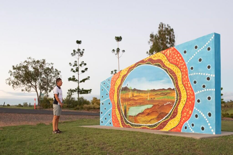
Meeting Place of the Waters Mural
The eye catching circular mural that is painted on the water tower at the pumping station was painted by Rain Hart in 1997. It depicts the meeting of the Boyne, Auburn and Burnett Rivers with lots of native flora and fauna tucked into the scenes.
- Where: Strathdee Street, Mundubbera
- Hours: Anytime
- Cost: Free
Mundubbera and District Historical Society’s Museum
‘Bicentennial Park’ is situate along the Burnett River foreshore and was established in 1988. This park includes a large variety of monuments and sculptures depicting those important events and people that shaped the township of Mundubbera, the surrounding district, and our nation, Australia.
It includes the site of the first ever road bridge to suspend the Burnett River and abuts the relatively new ‘Dimitrious Bridge’, opened on the 4th December 1982.
The beautifully restored C17 Steam Locomotive takes pride of place in eastern end of the park, a powerful reminder of the importance of the railway to the establishment of Mundubbera as a township.
- Where: Mundubbera-Durong Road, Mundubbera
- Hours: Mon, Fri and Sat 8:30am to 10:30am
- Cost: Free
Mundubbera Regional Art Gallery
Take the time to have a stroll down town and visit the Art Gallery opened in April 2008. The Gallery is climate controlled and capable of displaying national art works. Many exhibitions have been held including works by local and regional textile artists, silversmiths and quilters.
- Where: Lyons Street, Mundubbera
- Hours: Mon – Fri 10:00am to 4:30pm, Sat 9:00am to 12:00pm
- Cost: Free
Mundubbera Heritage and Information Centre
During your visit, view the displays on early settlement and local industries.
- Where: Mundubbera-Durong Road, Mundubbera
- Hours: Mon – Fri 10:00am to 4:30pm, Sat 9:00am to 12:00pm
- Cost: Free
Wain’s Hill Lookout
Take a drive along the Gayndah Mundubbera Road and follow the twists and turns of the Burnett River. Perched on a hill, Wain’s Hill Lookout gives a great view over the river and surrounding grazing land, owned by the Wain family, who have been residents in the district for many generations.
- Where: Gayndah-Mundubbera Road, Mundubbera
- Hours: Anytime
- Cost: Free

ACCOMMODATION IN GAYNDAH AND THE NORTH BURNETT REGION
Whether you are spending a night, a week or a month, the North Burnett region has some great value accommodation for you.
Biggenden
- Biggenden B&B – 260 Woowonga Hall Road, Biggenden
- Biggenden Motel – 44 Walsh Street / Isis Highway, Biggenden
- Edgehill Country Cottage – 251 Fairview Creek Road, Biggenden
- Grand Hotel – 27 Edward Street, Biggenden
- Mountain View Caravan Park – Walsh Street, Biggenden
- Paradise Dam Recreation Park – 353 Campbells Road, Biggenden
Eidsvold
- Eidsvold Caravan Park – 3 Esplanade Street, Eidsvold
- Star Hotel Motel – 1 Hodgkinson Street, Eidsvold
Gayndah
- Burnett Hotel – 1 Capper Street, Gayndah
- Country Roads Motor Inn – 56 Capper Street, Gayndah
- Gayndah A Motel – 4 Mick Lutvey Street, Gayndah
- Gayndah Colonial Motor Inn – 62 Capper Street, Gayndah
- Golden Orange Hotel Motel – 3-5 Maltby Place, Gayndah
- Grand Hotel – 4 Meson Street, Gayndah
- Riverside Motel, Caravan Park and Service Station – 11-15 Dalgangal Road, Gayndah
- Riverview Caravan Park – 3 Barrow Street, Gayndah
Monto
- Albert Hotel – 58 Newton Street, Monto
- Cania Cottages – 1 Shamrock Road, Cania
- Cania Gorge Tourist Retreat – 1253 Cania Road, Cania
- Monto Caravan Park – 16 Flinders Street, Monto
- Monto Colonial Motor Inn – 6 Thomson Street, Monto
- Waratah Hotel – 11903 Gladstone / Monto Road, Monto
Mount Perry
- Grand Hotel – 74 Heusman Street, Mount Perry
- Marchioness B&B Farmstay – 262 Harpurs Hill Road, Mount Perry
- Mingo Crossing Recreation Area – 2670 Gayndah-Mount Perry Road, Mount Perry
- Mount Perry Caravan park – 54 Heusman Street, Mount Perry
- Mount Perry Federal Inn – 87 Heusman Street, Mount Perry
- Pleasant Mountain Retreat – 1294 Gaeta Road, Gaeta
Mundubbera
- Billabong Motor Inn – 47 Strathdee Street, Mundubbera
- Jerakala Farmstay B&B – 20024 Burnett Highway, Mundubbera
- Mundubbera Motel – 42 Strathdee Street, Mundubbera
- Mundubbera Three Rivers Tourist Park – 37 Strathdee Street, Mundubbera
- Royal Hotel – 4 Lyons Street, Mundubbera
In Summary: Guide to Gayndah and the North Burnett Region
The North Burnett region is located approximately four hours’ drive north of Brisbane and one hour west of Bundaberg and as such, makes it easily accessible for a weekend trip away or a longer holiday.
The six main townships – Biggenden, Eidsvold, Gayndah, Monto, Mount Perry and Mundubbera – each offer something to suit everyone’s interests.
You will find the North Burnett region is a real contrast to the coastal areas and where you will experience the Australian country at its best.
Have you travelled through this region? What were your favourite areas? Please feel free to leave a comment below.
WANT TO READ MORE?
So, if you want to read more about our 1 month road trip in Queensland, click on the following post.
TRIP PLANNERS FOR AUSTRALIA: RELATED BLOG POSTS
Want more info to help you plan your Australia trip? Check out all the articles we’ve written on travel in Australia below and continue planning your trip.